
Moon Phase Today Manisa
On Sunday, October 4, 2026, the moon in Manisa is a Last Quarter with 45% illumination. Moon age: 22.6 days.
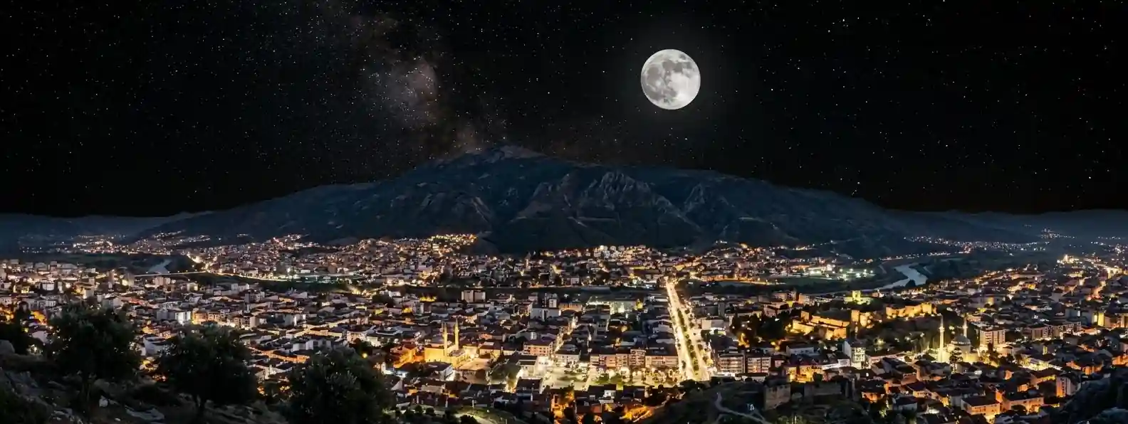
☽ Best Places to View the Moon in Manisa, Turkey
Manisa sits at the foot of Mount Spil on the edge of the Gediz Plain, so you get a low plain, lakes and volcanic fields and high ridges within a short drive. The Moon rises in the east, crosses the southern sky and sets in the west. Mount Spil rises just south of the city, so from the city the southern parts of the Moon's rising and setting range can be hidden behind the mountain, while the Gediz Plain and the summit give more open horizons. The area combines Lydian heritage, the Kula-Salihli UNESCO Global Geopark and national park forests. Exact Moonrise and Moonset directions change with the date and your observing position, so check both before planning a specific composition.
Mount Spil National Park – 1,517 m at Karatepe
Mount Spil, also known as Mount Sipylus, reaches 1,517 m at Karatepe, listed by the provincial geography, and it was designated a national park in 1969. It rises just south of Manisa, with paragliding fields and wide views over the city and the Gediz Plain. From the summit the Moon is behind you when you look north over the city, so use it for a high overlook above the city lights, and turn east or west for Moonrise or Moonset. Mountain weather can change quickly, so check conditions before an evening visit.
Bozdağlar – Kumpınar, Listed at About 2,070 m
The Bozdağlar are one of Manisa's major mountain systems, with Kumpınar listed at about 2,070 m. The elevated terrain offers potentially darker skies than the urban plain, although local cloud and atmospheric conditions can vary considerably. The range spans İzmir, Manisa and Aydın. It is a cold, exposed mountain environment, so check road and weather conditions before going.
Kula-Salihli UNESCO Global Geopark – Black Lava and Cinder Cones
The Geopark has more than 80 cinder cones, along with maars and lava flows, and the coal-black lava has been known since antiquity as Katakekaumene, the burnt land. The stark, open volcanic landscape gives dramatic foregrounds for the Moon. The lava is sharp underfoot, and volcanic dust can mark a lens, so stay on paths and check the park's rules.
Sardis & Bin Tepe – Lydian World Heritage Landscape
The ancient city of Sardis lies about 7 km west of Salihli, on the slopes of Mount Bozdağ. The Bin Tepe necropolis, 7 to 17 km north of the Sardis citadel according to UNESCO, contains more than 119 burial mounds, on the southern shore of Marmara Lake. Sardis and the Lydian Tumuli of Bin Tepe were inscribed as a UNESCO World Heritage Site in 2025. They are protected sites, so stay on paths and check current visiting arrangements.
Gölmarmara Lake (Marmara Lake) – Low Waterside Setting
Marmara Lake lies between Salihli and Gölmarmara in a tectonic depression, at about 74 m above sea level, with a surface area listed at about 12 km². It gives a low-elevation setting for Moon photography, although water levels and the shoreline vary. UNESCO documentation notes significant drying and discusses plans to restore water to the lake, so Moon reflections should not be promised as always available.
Demirci & the Northern Highlands – Bilim Demirci Science Centre
In the north of the province, Demirci Municipality's TÜBİTAK-supported science centre, Bilim Demirci, has held a sky-observation night where participants looked at the gibbous Moon through high-resolution telescopes, seeing craters, mountain ranges and lava plains. The Yunt and Demirci mountains around it, listed at about 1,074 m at Nemrut Tepe and about 1,800 m at Ziyaret Tepe, have forest clearings with less light pollution than the city. These are scheduled events, not nightly, so check announcements for dates.
◉ Best Times for Moon Photography in Manisa
📷 Quick Tips for Manisa
🕐 Timezone: Manisa uses Turkey Time (TRT), UTC+3, year-round. Turkey has used a single permanent time zone since September 2016 and does not observe daylight saving. Europe/Istanbul zone.
🔭 Telescope Option: A regular public telescope night is not widely advertised in Manisa itself. Bilim Demirci, the TÜBİTAK-supported science centre in Demirci, has held sky-observation nights with telescopes. Check its announcements for dates.
Access: Mount Spil is a national park, and Sardis and Bin Tepe are protected UNESCO sites, so check current park and site rules. Marmara Lake's water level varies. The Kula lava is sharp underfoot.
The moon phase today in Manisa is shown above. For moon phase today anywhere else, visit the calculator on our home page.
◐ What It Feels Like
On Mount Spil, the city lies below you with the Gediz Plain stretching beyond, and the wide views from the paragliding fields suit night-sky observation.
In the Kula-Salihli Geopark, the black lava and the more than 80 cinder cones create a stark, open landscape, and the Moon rises over a field the ancient Greeks called the burnt land.
At Sardis and Bin Tepe, the ancient Lydian capital and its burial mounds face a wide plain with broad horizons, a World Heritage landscape inscribed in 2025.
"From the plain and a shallow lake to Mount Spil just above town and the high Bozdağlar — Lydian tumuli and black volcanic fields under the Moon."
✓ Checklist for Lunar Observers
Before You Go
- Check moonrise and moonset azimuth for your date and spot — Mount Spil can hide the southern parts of the range from the city
- Check the MGM forecast — mountain weather can change quickly, and the lake level varies
- Confirm access: Mount Spil National Park, the Kula-Salihli Geopark, and Sardis and Bin Tepe
What to Bring
- Telephoto 200 mm or longer, and a wide lens for the tumuli and lava fields
- Tripod for landscapes and bracketing — a close-up Moon can be shot handheld with a fast shutter
- Lens cloth for volcanic dust
- A warm layer — Spil and the Bozdağlar are much colder than the plain
On the Night
- Manual focus on the lunar limb or a distant object
- Bracket for the disc and the lava, forest and lake foreground
- Stay on paths — the national park and UNESCO sites are protected, and the lava is sharp
- Treat the higher ground as better skies, not dark-sky sites
? Manisa Moon Phase — Frequently Asked Questions
Q. What is the moon phase today in Manisa?
The moon phase today in Manisa is a Last Quarter with 45% illumination. The next full moon is in 23 days, on 26 Oct. Moonrise is at — and moonset at 3:29 PM.
Q. Where is the best place to view the moon in Manisa?
Manisa sits at the foot of Mount Spil, on the edge of the Gediz Plain, so you can view the moon from low plain or high mountain. Mount Spil, a national park since 1969, rises to about 1,517 m just south of the city and has paragliding fields with wide views. Marmara Lake (Gölmarmara) gives a low waterside setting, though its water levels vary. The ancient Lydian capital of Sardis and the Bin Tepe burial mounds, inscribed as a UNESCO World Heritage Site in 2025, give historic foregrounds, and the Kula-Salihli Geopark has black lava and cinder cones. The Bozdağlar range inland is higher and darker.
Q. Can I look at the moon through a telescope in Manisa?
Occasionally. Bilim Demirci, the TÜBİTAK-supported science centre run by Demirci Municipality in the north of the province, has held sky-observation nights where participants looked at the gibbous moon through high-resolution telescopes and saw craters, mountain ranges and lava plains. A regular public telescope night is not widely advertised in Manisa itself, so check the science centre's and the municipality's announcements for dates, since observing depends on the weather.
Q. Where does the moon rise and set in Manisa, and how high does it climb?
At about 38.6°N, Manisa's moonrise and moonset points swing widely across the horizon each month, from roughly east-north-east to east-south-east for rising and west-north-west to west-south-west for setting, with an even wider swing in years near a major lunar standstill. A full moon near the winter solstice climbs to roughly 75° in the south, while a full moon near the summer solstice stays lower, peaking near 28°. Mount Spil rises just south of the city, so from the city the southern parts of the rising and setting range can be hidden behind the mountain, and the Moon crosses the sky above it. From the Gediz Plain and the summit the horizons are more open. Check the azimuth for your date and exact spot.
Q. Is light pollution a problem for moon observing in Manisa?
The moon is bright enough to observe and photograph from almost anywhere in Manisa, so light pollution rarely limits the lunar disc itself. It does wash out earthshine on a thin crescent and any faint sky detail. The city and the busy Gediz corridor toward İzmir are lit, so stars are faint on the plain. The highlands, such as Bozdağlar, the Yunt and Demirci mountains and the Kula lava fields, are darker, though no measured dark-sky designation is listed for them, so treat them as better, not dark.
Q. What camera settings and phases work best for moon photography in Manisa?
For a full moon, start with Looney 11 (f/11, ISO 100, 1/100 s) and refine using your histogram, since it is a baseline rather than a guarantee. The moon is much brighter than the lava fields, the forest and the plain, so shoot RAW and bracket or blend exposures to keep both crater detail and the foreground. A waxing gibbous suits blue hour at Spil and the Kula lava fields while the foreground is still lit. For close-ups the moon is bright enough to shoot handheld with a fast shutter, while a longer lens helps for distant tumuli, which look small against the sky, and manual focus on the moon's edge works best.
Q. How do mountain weather, haze and heat affect moon viewing in Manisa?
Manisa has an Aegean climate with hot, dry summers, and summer haze can lower contrast. Mountain weather, especially on Mount Spil and the Bozdağlar, can change quickly, so check the Turkish State Meteorological Service forecast for cloud and visibility shortly before you go. The highlands are much colder than the plain, so bring a warm layer, and volcanic dust in the Kula fields can mark a lens.
Q. What time zone are Manisa's moonrise and moonset times shown in?
Manisa runs on Turkey Time, UTC+3, all year. Turkey has used a single permanent time zone since September 2016 and does not change its clocks. Moonrise and moonset times on this page follow the local clock. Manisa lies at about 27.4°E, well west of the 45°E meridian on which UTC+3 is based, so the sun and moon cross the sky about 70 minutes later on the clock than they would on that meridian.
Q. Can I shoot the moon at Manisa's viewpoints after dark?
Mostly, with care, but check each place. Mount Spil is a national park, so follow its rules and take care on the mountain after dark. The UNESCO sites at Sardis and Bin Tepe are protected, so stay on paths and check current visiting arrangements. The Kula lava is sharp underfoot, and Marmara Lake's water level varies, so reflections are not always available. Check road and weather conditions before going to the Bozdağlar.
✦ Explore Further
Moon Phase Today: Izmir
Check tonight's moon phase in Izmir, roughly 35 km south-west of Manisa on the Aegean coast.
🏛Moon Phase Today: Aydın
See the moon over Aydın, roughly 95 km south-south-east of Manisa in the Büyük Menderes valley.
🌍World Moon Phase Directory
Find the moon phase, rise and set times for cities in every region of the world.
Blue Hour Calculator
Work out when blue hour falls, ideal for waxing gibbous shots over the Gediz Plain.