
L80 Orientale Basin
The Moon’s youngest and best-preserved multi-ring basin, its concentric rings almost entirely unflooded by lava — a genuine limb challenge that rewards favorable libration with one of the clearest bullseyes in the sky.
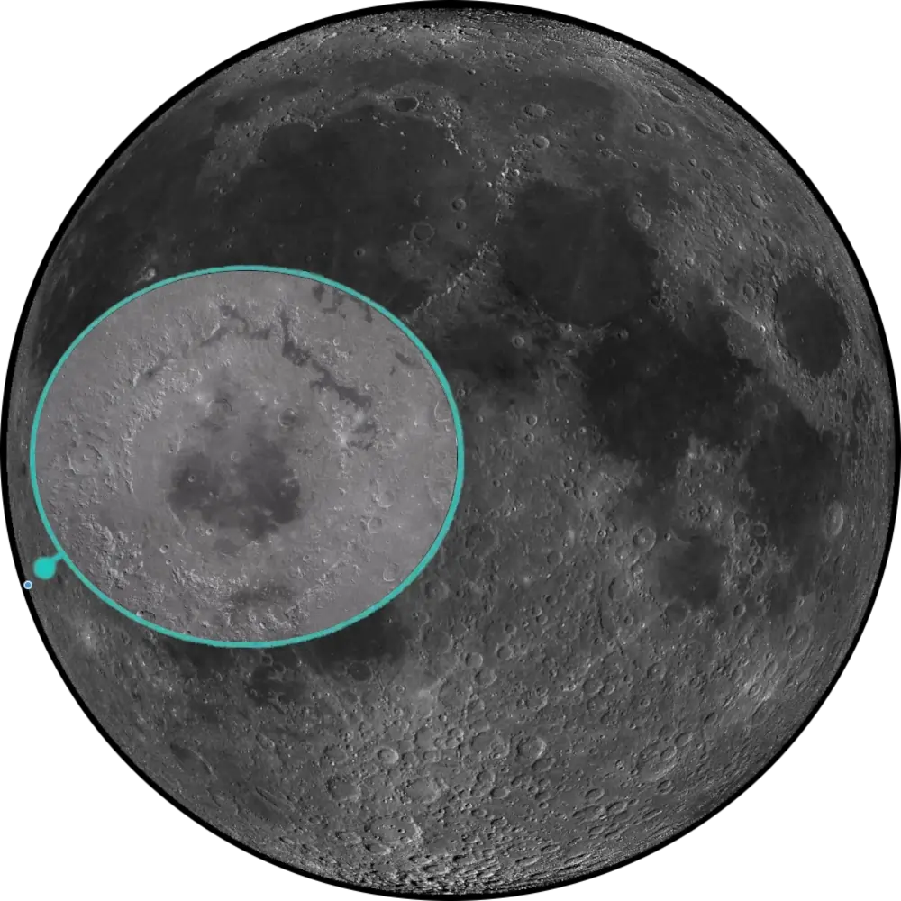
L80 Orientale Basin
Western Limb · Youngest Large Basin📉 Vital Statistics
🔭 Field Notes
Orientale sits far enough onto the western limb, bordering the far side, that seeing any of it at all requires favorable libration. When conditions cooperate, look for a compressed, foreshortened “bullseye” of concentric ridges near the terminator — this is one of the few places on the Moon where you can actually trace multiple complete impact rings in a single view, rather than the single crumbling rim of an ordinary basin.
- ▶ A Name That No Longer Fits: “Orientale” is Latin for “eastern,” a name assigned under the old, pre-1961 convention for lunar east and west. When the IAU adopted the modern convention in 1961 to bring lunar maps into line with ordinary terrestrial map conventions (north up, east to the right), the “Eastern Basin” ended up, ironically, on the Moon’s western limb — where it remains today.
- ▶ A Bullseye Almost Never Flooded: Unlike Imbrium, Serenitatis, or Crisium, Orientale’s interior was only thinly covered by mare basalt — the central Mare Orientale deposit is generally estimated at under a kilometer thick, leaving the basin’s three great rings, the Cordillera, Outer Rook, and Inner Rook, largely exposed. Two further basalt ponds, Lacus Veris and Lacus Autumni, sit in the troughs along the bases of the Outer Rook and Cordillera rings respectively, making Orientale the standard reference basin for studying how multi-ring impact structures actually form.
- ▶ Built by Giant Faulting: Modeling of the basin’s outer two rings, the Cordillera and Outer Rook, indicates they formed through large-scale normal faulting — essentially colossal slumping of the crust — the same basic process that builds terraces in ordinary complex craters, just at a vastly larger scale, rather than requiring a single continuous megaterrace or overturned debris flap.
📍 Nearby L100 Targets
- L44 Mersenius: The 84 km crater roughly 1,300 km east, considerably older (Nectarian) than Orientale itself, with its own parallel rille system, Rimae Mersenius, cutting across its floor.
- L52 Crüger: A 45 km crater roughly 815 km east-northeast, notable for one of the darkest, lowest-albedo floors anywhere on the Moon — a striking contrast to Orientale’s bright, largely unflooded ring structure.
- L77 Sirsalis Rille: A roughly 330 km linear rille system roughly 1,030 km northeast, running from the shore of Oceanus Procellarum to the crater Darwin — a tectonic fracture feature, distinct in scale and origin from Orientale’s basin-forming impact rings.
🚀 Mission Log
Target Acquisition
Aim for the western limb — and check libration first
Orientale sits at 19.0°S, 95.0°W, so far onto the western limb that it its centre lies just beyond the western near-side boundary, with the basin straddling the limb. On Rükl chart 50, this isn’t a target you can just look up and find on any given night — check a libration table or planetarium app first, since seeing any of the basin at all depends on the Moon tipping favorably in your direction.
Combine favorable libration with terminator timing
Even with good libration, Orientale needs a low sun angle to show its structure — catch it near the terminator so the ring topography throws shadow rather than washing out under flat lighting. The basin will always look compressed and foreshortened this close to the limb, so don’t expect the tidy bullseye you’d see from directly overhead; you’re viewing nearly edge-on.
Trace the three rings, then hunt for the mare ponds between them
Work outward from the centre: the Inner Rook, Outer Rook, and Cordillera rings form one of the clearest examples on the Moon of a multi-ring impact basin — and topographic surveys count at least four rings total within the Cordillera rim, with several enormous concentric mountain systems stacked one beyond another. Between the rings, look for two small basalt ponds — Lacus Veris along the Outer Rook’s base and Lacus Autumni along the Cordillera’s — modest patches of mare in a basin whose interior is strikingly sparsely flooded compared with the maria-covered basins of the near side.
From Orientale to Mersenius, Crüger, and the Sirsalis Rille
East, roughly 1,300 km away, Mersenius (L44) is an 84 km crater considerably older than Orientale, cut by its own Rimae Mersenius rille system. East-northeast, about 815 km off, Crüger (L52) is a 45 km crater with one of the darkest floors anywhere on the Moon — a striking contrast to Orientale’s bright, largely unflooded rings. And northeast, roughly 1,030 km distant, the Sirsalis Rille (L77) is a 330 km linear tectonic fracture running from Oceanus Procellarum to the crater Darwin — a fault feature of an entirely different scale and origin from Orientale’s impact-built rings.
📝 Observation Log — L80 Orientale Basin
0/4 CompleteIs Orientale Basin visible tonight?
Orientale sits at 19.0°S, 95.0°W, so far onto the western limb that its centre lies just beyond the near-side boundary. Seeing any of it at all depends on favorable western libration — check a libration table before you look. Even with good libration, you’ll also want a low sun angle near the terminator, so the ring topography throws shadow instead of washing out flat.
Check Moon Phase TodayReturn to the List
Ready to find the next target? Go back to the full map to see what else is visible tonight.
← Back to Lunar 100 Map
When to Observe Orientale Basin
Most Lunar 100 targets ask for one favorable condition. Orientale asks for two, stacked together: without favorable western and southern libration the basin’s structure is largely compressed out of view, and without a low sun angle you won’t see its structure once it’s in view.
- Check Libration First — Nothing Works Without It: Orientale sits at 19.0°S, 95.0°W on the extreme western limb, straddling the near-side/far-side boundary. Check a libration table or planetarium app before planning a session — favorable western and southern libration together give you the best chance of seeing the basin’s structure at all.
- Then Combine It With a Low Sun Angle: Even with good libration, Orientale needs a low sun angle to show its structure — catch it near the terminator so the ring topography throws shadow rather than washing out under flat lighting. Expect a compressed, foreshortened view, not a tidy overhead bullseye.
- For Orientation: On Rükl chart 50, this isn’t a target you find by hopping from a nearby landmark — it’s a target you find by waiting for the right night, since the limb geometry largely determines whether the basin’s structure will be accessible at all.
What to Look For
Once you have Orientale in view, look for the nested Inner Rook, Outer Rook, and Cordillera ring structures — one of the clearest examples on the Moon of a multi-ring impact basin, even though Earth’s vantage point compresses the rings almost edge-on.
Look for Lacus Veris along the Outer Rook’s base and Lacus Autumni along the Cordillera’s — modest basalt patches in a basin whose interior is strikingly sparsely flooded compared with the maria-covered basins of the near side.
“Orientale” is Latin for “eastern,” a name assigned under the old, pre-1961 convention for lunar east and west. When the IAU adopted the modern convention in 1961 to bring lunar maps into line with ordinary terrestrial map conventions, the “Eastern Basin” ended up, ironically, on the Moon’s western limb — where it remains today.
Modeling of the basin’s outer two rings, the Cordillera and Outer Rook, indicates they formed through large-scale normal faulting — essentially colossal slumping of the crust, the same basic process that builds terraces in ordinary complex craters, just at a vastly larger scale.
The Science: The Moon’s Premier Multi-Ring Basin
Orientale isn’t just a hard target to catch — it’s the standard reference basin for understanding how multi-ring impact structures form anywhere on the Moon, precisely because so little lava ever buried the evidence.
Vital Statistics
Located at 19.0°S, 95.0°W on Rükl chart 50, Orientale spans 930 km across its outer Cordillera ring. It’s the Moon’s youngest and best-preserved large multi-ring impact basin, forming roughly 3.8 billion years ago, shortly after the Imbrium impact and early in the Imbrian period. Its L100 distinction: the Moon’s premier example for studying how multi-ring impact basins form, though a genuine limb-and-libration challenge for Earth-based observers.
A Bullseye Almost Never Flooded
Unlike Imbrium, Serenitatis, or Crisium, Orientale’s interior was only thinly covered by mare basalt — the central Mare Orientale deposit is generally estimated at under a kilometer thick, leaving the basin’s three great rings largely exposed. Two further basalt ponds, Lacus Veris and Lacus Autumni, sit in the troughs along the bases of the Outer Rook and Cordillera rings respectively, making Orientale the standard reference basin for studying how multi-ring impact structures actually form.
Mission Record
Lunar Orbiter IV captured the first detailed orbital view of Orientale in 1967, revealing its concentric ring structure and establishing it as a key target for basin-formation studies. Clementine’s 1994 global altimetry and multispectral imaging provided detailed topography and composition data across the basin’s rings and interior mare patches. GRAIL’s 2011–2012 high-resolution gravity mapping revealed the basin’s subsurface density structure and mascon, including a continuous ring dike along the Outer Rook fault, sharpening the picture of the basin’s buried architecture.
Most Lunar 100 targets are chosen for what they look like. Orientale was chosen for what it teaches — a basin young enough, dry enough, and well-preserved enough to show, ring by ring, exactly how the Moon’s largest impact structures were built.