Spring tides vs neap tides — why the sea doesn't behave the same way twice
Every two weeks the ocean swings between extremes. Spring tides push the sea to its highest highs and lowest lows. Neap tides barely move it at all. The difference comes down to where the Moon and Sun sit relative to Earth — and the widget below shows that geometry right now.
Spring tides vs neap tides — why the moon determines how far the sea will reach
Twice a month the ocean goes to extremes — surging higher and falling lower than at any other point in the lunar cycle. Twice a month it does the opposite, barely moving at all. The difference between these two states is one of the most consistent and predictable patterns in nature, and it is written entirely in the geometry of the Moon, the Sun, and the Earth.
What actually causes tides
Tides are not waves in the conventional sense. They are long, slow deformations of the ocean caused by the gravitational pull of the Moon and, to a lesser extent, the Sun. As the Moon orbits Earth, its gravity tugs at the ocean on the near side, pulling water toward it and creating a bulge of elevated water. Simultaneously, a second bulge forms on the opposite side of Earth — not because the Moon is pulling the water there, but because it is pulling the Earth itself slightly away from that water.
The result is that at any given moment, two high-tide bulges exist on opposite sides of the planet. As the Earth rotates beneath them, coastal locations pass through these bulges roughly twice every 24 hours — which is why most coastlines experience two high tides and two low tides each day.
The Sun exerts a gravitational pull on the oceans too, but because it is so much farther away, its tidal effect is only about 46% as strong as the Moon's. That fraction is significant enough to dramatically alter tidal range when it aligns with — or works against — the Moon's pull.
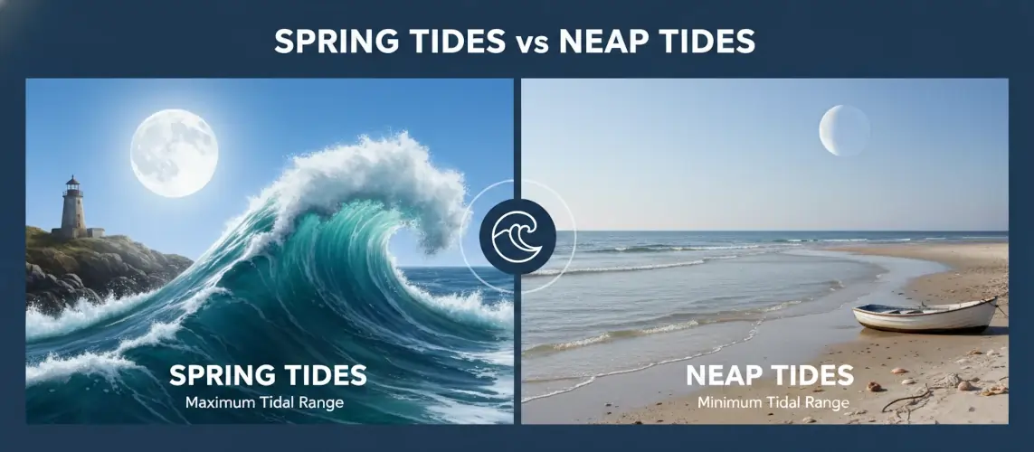
Spring tides, neap tides, and king tides — the three states
The tidal range at any location fluctuates over the lunar month in a predictable two-week cycle, moving between two extremes. A third state — rarer and more dramatic — occurs when the geometry aligns perfectly.
Every ~14 days
Spring Tide
Sun, Earth, and Moon align during full and new moon. The Sun's gravity reinforces the Moon's, pushing high tides higher and pulling low tides lower. Tidal range is at its maximum. The name has nothing to do with the season — it comes from the old English sense of water "springing forth."
Every ~14 days
Neap Tide
Moon is at a right angle to the Sun, at first and third quarter phases. The Sun's gravitational pull partially cancels the Moon's, moderating both high and low tides. The difference between high and low is at its smallest — the ocean at its most subdued.
A few times per year
King Tide
A spring tide that coincides with the Moon being at perigee — its closest point to Earth in its elliptical orbit. The extra gravitational pull amplifies the already-high spring tide, producing the largest tidal range of all. Coastal flood risk is elevated during king tides.
A common misconception — new moon tides are just as extreme as full moon tides
Many people assume only the full moon drives strong tides. In fact, alignment — not illumination — is what matters. During a new moon, the Moon is between the Earth and the Sun: all three are aligned and their gravitational forces combine exactly as they do at full moon. Spring tides occur at both. The Moon's lit face being hidden from us makes no difference to the physics.
Spring tides vs neap tides — a direct comparison
| Feature | Spring tide | Neap tide |
|---|---|---|
| Moon phase | Full moon or new moon | First or third quarter |
| Sun–Moon angle | 0° or 180° (aligned) | 90° (right angle) |
| Gravitational forces | Sun and Moon reinforce each other | Sun and Moon partially cancel |
| Tidal range | Maximum — highest highs, lowest lows | Minimum — moderate highs and lows |
| Frequency | Twice per lunar month (~every 14 days) | Twice per lunar month (~every 14 days) |
| Time between | Approximately 7 days separates each spring tide from the following neap tide | |
| Typical range increase | ~20% above mean | ~20% below mean |
Where the physics becomes spectacular — the Bay of Fundy
The same tidal forces produce very different results in different locations, depending on ocean basin shape, depth, and a phenomenon called tidal resonance. The clearest example of what spring tides can do when geography amplifies them is the Bay of Fundy in eastern Canada.
The Bay of Fundy is funnel-shaped and narrows dramatically toward its head. The natural oscillation period of water sloshing back and forth in the bay — roughly 12.4 hours — happens to closely match the 12.4-hour period of the lunar tide. Each incoming Atlantic tide gives the previously reflected wave an almost perfectly timed push, building on itself the way a child pumping a swing builds momentum. The result is a tidal range that reaches up to 16 metres at Burntcoat Head in Nova Scotia's Minas Basin — the highest reliably recorded tides on Earth.
Tidal bores — when the tide becomes a river wave
At the Bay of Fundy and a handful of other locations worldwide, the incoming spring tide pushes so much water so quickly into river mouths that it creates a tidal bore — a standing wave that travels upstream against the river's natural flow. On the Shubenacadie River, tidal bores travel at around 15 km/h, generating rapids up to 3.5 metres high in their wake. Surfers have ridden the Petitcodiac River bore for over 29 kilometres in a single run.
Most coastlines experience nothing as extreme as the Bay of Fundy. The global average tidal range is around 1 metre. But the principle is the same everywhere: spring tides push the ocean to its limits; neap tides hold it back. The local geography determines how dramatically that plays out.
How spring and neap tides affect marine life
The fortnightly swing between spring and neap tides is not just a coastal engineering consideration — it drives the rhythm of entire marine ecosystems. For many species, the tidal cycle is as fundamental a timer as the seasons.
Spring tides expose more of the intertidal zone — the band of shoreline between the highest and lowest tide marks. This larger exposure means more foraging ground for shorebirds and wading species, and more time for intertidal organisms like anemones, mussels, and barnacles to feed during submersion. The increased water movement also stirs up nutrients from the seabed, driving phytoplankton blooms in coastal shelf waters. Research has shown that chlorophyll concentrations during spring tides can reach up to 1.7 times higher than during neap tides, and the growth of many fish species follows a corresponding fortnightly peak shortly after each spring tide.
Neap tides provide a period of relative calm — reduced turbulence, more stable salinity gradients, and less sediment disturbance. Estuaries and tide pools that were scoured by spring tides begin to settle. Some spawning species time their releases to neap tides specifically to reduce the risk of eggs being dispersed before fertilisation.
Horseshoe crabs and the spring tide
One of the most dramatic examples of spring tide synchronisation occurs on the beaches of Delaware Bay in the United States each May and June. Hundreds of thousands of horseshoe crabs emerge from the ocean to spawn on the high-tide line during spring tides, their timing so precise that it represents one of the most predictable wildlife events in North America. The high spring tide carries their eggs to exactly the right depth in the sand. Shorebirds migrating thousands of kilometres north time their stopover to coincide with the feast.
King tides and coastal flood risk
King tides — perigean spring tides — occur when a spring tide coincides with the Moon reaching perigee, the closest point in its elliptical orbit. The Moon's gravitational pull increases with proximity, so a perigean spring tide produces a measurably larger tidal range than an ordinary spring tide. These events happen several times a year and are entirely predictable months in advance from lunar orbital data.
King tides matter increasingly in the context of sea level rise. They are used by coastal managers and climate scientists as a preview of what future mean sea levels will look like — the flooding a king tide produces today represents roughly what a moderate tide will produce in coming decades as baseline sea levels rise. Cities that track king tide inundation now are effectively mapping their future flood risk.
When king tides coincide with storm surge
The most dangerous coastal flooding events occur when a king tide coincides with an onshore storm surge — wind and low atmospheric pressure pushing extra water toward the coast simultaneously. The highest water level ever recorded in the Bay of Fundy, 21.6 metres in October 1869, was the product of an extreme spring tide combined with a two-metre storm surge from a tropical cyclone. The tidal component alone would have been remarkable; the storm surge made it catastrophic.
Reading the tide — practical questions answered
How do I know if today is a spring tide or a neap tide?
Look at the Moon phase. If it is full or new, you are in a spring tide window. If it is at first or third quarter — half illuminated — you are in a neap tide window. The spring tide peaks roughly 1–2 days after the full or new moon rather than precisely on it, due to a lag called the age of the tide caused by the ocean's inertia.
Does spring tide mean higher waves?
Not directly. Waves are driven by wind and swell, not by tides. However, spring tides produce stronger tidal currents as more water moves in and out over the same period, and the higher water level means waves break further up the beach and can overtop coastal structures that are safe during neap conditions.
Why don't all spring tides reach the same height?
Several factors modulate each spring tide: the Moon's distance from Earth at that moment (perigee vs apogee), the Sun's distance (Earth is slightly closer to the Sun in January), local weather, and the angle of the Moon's orbit relative to the equator. No two spring tides are identical, which is why tide tables are calculated individually for each location and date rather than from a simple formula.
Are there places that only get one tide per day?
Yes. Most coastlines are semi-diurnal — two high tides and two low tides per day — but some locations, including parts of the Gulf of Mexico and Southeast Asia, experience diurnal tides with only one high and one low each day. This is determined by the shape of the ocean basin and how tidal waves propagate through it, not by the Moon's behaviour changing.
Practical notes for divers, anglers, and coastal visitors
"The tide is faithful. It has never missed an appointment in the history of the ocean."
Moonphase Today — Tides & Oceans