
L89 Valentine Dome
A heart-shaped swelling on the shore of Mare Serenitatis, so subtle it vanishes under anything but the lowest grazing light — and may never have erupted at all.
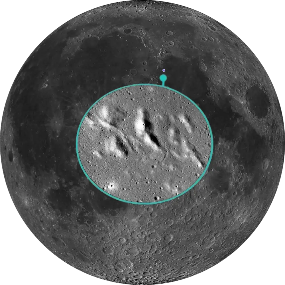
L89 Valentine Dome
NW Mare Serenitatis · Intrusive Dome📉 Vital Statistics
🔭 Field Notes
Tucked against the northwestern shore of Mare Serenitatis, right where the mare narrows into the gap toward Mare Imbrium near the Caucasus Mountains, the Valentine Dome is one of the Moon’s largest low-relief mare domes — yet so subtly raised that it’s essentially invisible except under the lowest possible sun angle. Rather than resembling a steep hill, it appears as an almost imperceptible swelling of the mare surface, detectable mainly by the way the terminator bends as it crosses. It was never part of the original IAU nomenclature; lunar observer Alika Herring first described it in a 1962 Sky & Telescope article as the “Plateau near Linné,” and the feature later received the official IAU designation Linné Alpha. Herring himself suggested the more evocative “Valentine Dome” name in 1966, after its heart-shaped outline under certain lighting, and that name has stuck with observers ever since — though it has never itself been an official IAU designation.
- ▶ A Heart By Lighting Only: The dome’s heart-like shape only emerges under the lowest sun angles near the terminator; at higher illumination it fades away almost entirely, leaving little trace beyond a handful of small hills scattered across its summit.
- ▶ Volcanic Dome, Reconsidered: Originally mapped as a straightforward volcanic dome in the 1960s, later analysis of its shape and structure has led some researchers to favor an intrusive laccolith interpretation instead — a body of magma that pushed up and domed the overlying crust from below, without necessarily erupting onto the surface.
- ▶ A Fault and a Rille: A fault uplifts the dome’s eastern margin, while a separate rille running northwest-to-southeast cuts directly across the structure — features consistent with tectonic stresses associated with the dome’s evolution, best seen alongside a smaller, 11 km companion dome just to the north.
📍 Nearby L100 Targets
- L41 Bessel Ray: A solitary, high-albedo ray of disputed origin crossing Mare Serenitatis further east — a target needing high, flat sun to show its brightness, the opposite lighting condition from the low grazing angle that reveals Valentine Dome’s subtle relief.
- L71 Sulpicius Gallus Dark Mantle: A pyroclastic ash blanket further south along the same Serenitatis shoreline, formed by explosive fire-fountain eruptions rather than the slow intrusive doming seen here — two very different styles of lunar volcanism within the same general neighborhood.
- L82 Linné Crater: A tiny, geologically young crater roughly 100 km southeast, alone on the floor of western Mare Serenitatis and famous for an 1866 controversy over whether its appearance had genuinely changed — the very feature Herring’s original 1962 article named the dome’s plateau after.
🚀 Mission Log
Target Acquisition
Find the gap between Serenitatis and Imbrium
Locate the northwestern rim of Mare Serenitatis, near the Caucasus Mountains and close to the interface where the mare narrows toward Mare Imbrium. The Valentine Dome sits on that shoreline as a broad, 30 km rise standing barely 130 m tall — so gentle a slope that on a featureless stretch of mare, you’re really hunting for a swelling in the terrain rather than any kind of hill.
Catch it right on schedule, about a week from New Moon
This is about as lighting-dependent as a target gets on this list: observers’ guides put the Valentine Dome’s viewing window at roughly Day 7 after New Moon (and the equivalent point in the waning cycle), when the terminator sits close enough for a shallow-angle Sun to catch the swelling. Miss that narrow window and the dome’s relief fades into the surrounding mare until the next lunation brings the terminator back around.
Watch the terminator bend, then look for the rille
At 150x–250x, the clearest tell isn’t the dome’s outline at all — it’s the way the terminator line itself bends slightly as it crosses the swelling, before the heart-like shape resolves on its own. Once you have it, look for the rille cutting across the dome: it’s often described as a genuine test object for telescope and seeing quality, sharp enough to reward a steady night. The smaller, 11 km companion dome just to the north is a good secondary catch in the same session.
From Valentine Dome to Bessel Ray, Sulpicius Gallus, and Linné
Further east across Mare Serenitatis, the Bessel Ray (L41) is a solitary, high-albedo streak of disputed origin — best seen under high, flat sunlight, the opposite lighting condition from the low grazing angle that reveals this dome’s relief. South along the same shoreline, the Sulpicius Gallus Dark Mantle (L71) is a pyroclastic ash blanket from explosive fire-fountain eruptions, a very different style of volcanism from the dome’s slow intrusive doming. And roughly 100 km southeast, Linné (L82) is a tiny, geologically young crater alone on the mare floor, famous for an 1866 controversy over whether its appearance had genuinely changed — the very feature Herring’s original 1962 article described as the “Plateau near Linné.”
📝 Observation Log — L89 Valentine Dome
0/4 CompleteIs Valentine Dome visible tonight?
Valentine Dome sits on the northwestern shore of Mare Serenitatis near 30.5°N, 10.1°E, and this is one of the most lighting-dependent targets on the list. Standing barely 130 m tall across a 30 km footprint, its relief only shows up during a narrow window around Days 6–8 after New Moon (depending on libration), when a shallow terminator catches the swelling. Watch for the terminator line bending across the dome before any heart-like outline appears.
Check Moon Phase TodayReturn to the List
Ready to find the next target? Go back to the full map to see what else is visible tonight.
← Back to Lunar 100 Map
When to Observe Valentine Dome
Few Lunar 100 targets are as lighting-dependent as this one. The Valentine Dome rises barely 130 m above a 30 km footprint — a slope so gentle that at most Sun angles it simply vanishes into the surrounding mare, leaving nothing to see at all.
- Catch a Narrow Window: Observers’ guides put the viewing window at roughly Days 6–8 after New Moon, depending on libration, or the equivalent point in the waning cycle, when a shallow-angle terminator sits close enough to catch the swelling. Miss it and the dome fades back into the mare until the next lunation.
- Watch the Terminator, Not the Outline: The clearest tell isn’t the dome’s shape at all — it’s the way the terminator line bends slightly as it crosses the swelling, before any heart-like outline resolves on its own.
- For Orientation: Locate the northwestern rim of Mare Serenitatis, near the Caucasus Mountains, close to where the mare narrows toward Mare Imbrium. The dome sits right on that shoreline.
What to Look For
At 30 km across and only about 130 m tall, Valentine Dome is one of the Moon’s largest low-relief mare domes — yet so subtly raised that on a featureless stretch of mare, you’re hunting a swelling in the terrain rather than any kind of hill.
The dome’s heart-like shape only emerges under the lowest sun angles near the terminator; at higher illumination it fades away almost entirely, leaving little trace beyond a handful of small hills scattered across its summit.
A fault uplifts the dome’s eastern margin, while a separate rille runs northwest-to-southeast directly across the structure. See whether hints of it can be detected under excellent seeing — it’s a genuine test of telescope and seeing quality, not an easy catch.
Just north of the main structure sits an 11 km companion dome roughly 80 m tall — a good secondary catch in the same session, and a useful comparison for judging how subtle the main dome’s own relief really is.
The Science: Volcano or Laccolith?
Valentine Dome’s real interest isn’t just its shape but what’s underneath it — whether it formed by lava erupting onto the surface or by magma lifting the crust from below.
Vital Statistics
Located at 30.5°N, 10.1°E, on Rükl chart 13, Valentine Dome spans 30 km with a maximum height of about 130 m. A companion dome, V2, measures 11 km and stands roughly 80 m tall. Its L100 distinction: volcanic dome.
Volcanic Dome, Reconsidered
Originally mapped as a straightforward volcanic dome in the 1960s, later analyses have suggested that it may instead be an intrusive laccolith — a body of magma that pushed up and domed the overlying crust from below, without necessarily erupting onto the surface. A 2024 mapping study using LRO and Chandrayaan-1 data went further, identifying an entirely new, previously unrecognized dome southeast of the main structure, suggesting the dome complex is more extensive than previously recognized.
Mission Record
Lunar Orbiter 4 photographed the Serenitatis-Imbrium boundary region in 1967, providing valuable orbital imagery for subsequent geological mapping of the dome. Digital elevation models derived from Earth-based telescopic imagery by Wöhler and Lena (2009) measured the dome’s true height and that of its smaller companion, providing key topographic evidence supporting the laccolith interpretation. Lunar Reconnaissance Orbiter, in orbit since 2009, has enabled recent geostratigraphic mapping via high-resolution LROC imagery, refining the picture of the fault and rille cutting across the dome.
Alika Herring first described this feature in a 1962 Sky & Telescope article as the “Plateau near Linné,” before proposing the name “Valentine Dome” in 1966 after noticing its heart-like shape — a name that stuck with observers even though it was never adopted by the IAU.