
L77 Sirsalis Rille
One of the Moon’s longest, straightest tectonic scars — a graben cutting almost entirely across highland terrain, following no mare margin and demanding no special libration or lighting to trace.
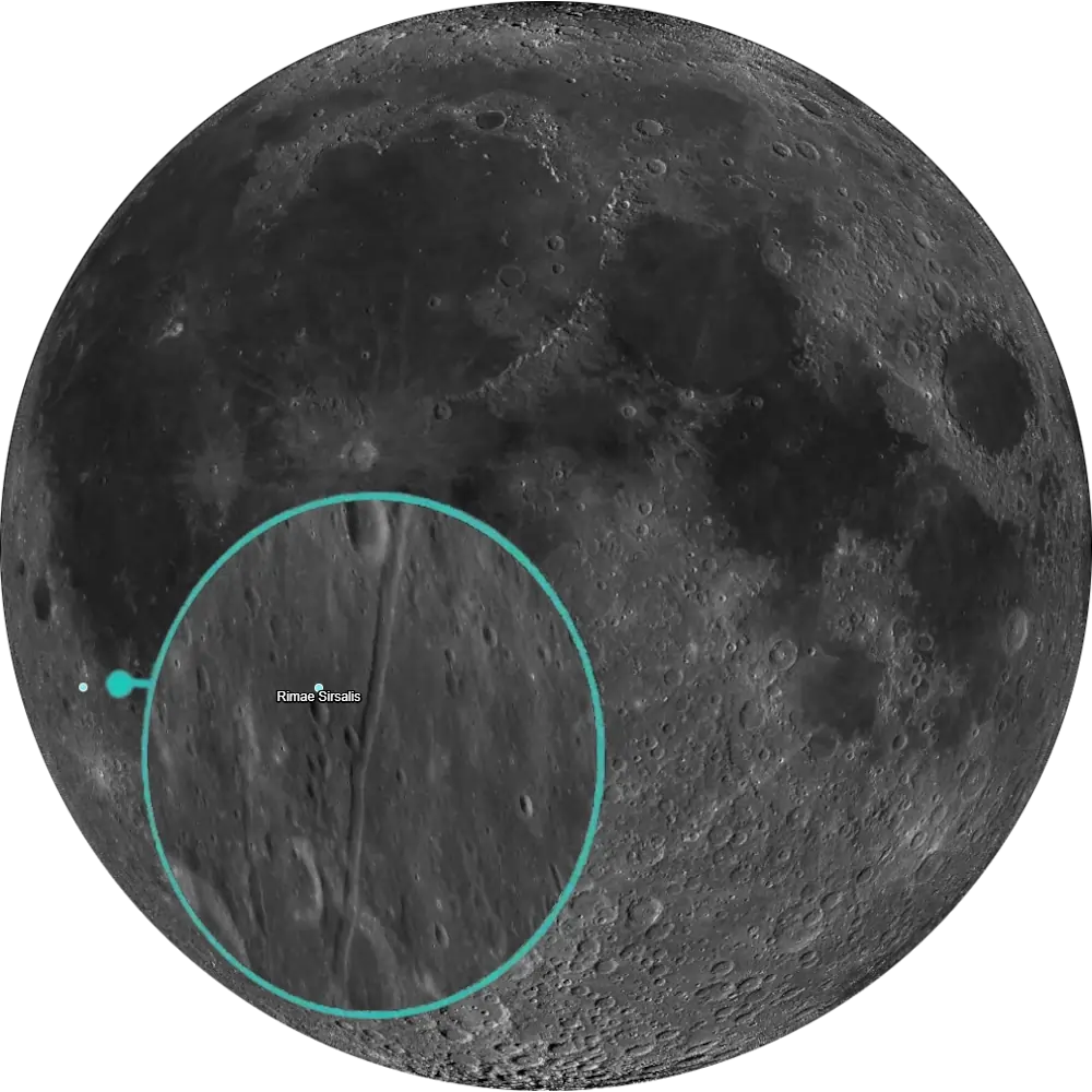
L77 Sirsalis Rille
Southwestern Oceanus Procellarum · Radial Graben📉 Vital Statistics
🔭 Field Notes
Rima Sirsalis needs no special libration or lighting trick to find — it’s one of the Moon’s most conspicuous rilles, and the principal rille is unusually straight, followable across much of its course in telescopic images and good observing conditions. Trace it along its run and you’ll cross highland terrain almost the entire way, an unusual path for a rille, before it reaches the Darwin region, where it intersects the Rimae Darwin system.
- ▶ A Graben, Not a Riverbed: Despite its river-like appearance, Sirsalis Rille is a graben — a strip of crust that dropped between two parallel faults as the surface pulled apart. Modeling of the fault geometry has suggested this could be the surface signature of a buried volcanic dike roughly 600 meters wide, with its top estimated around 2.4 km below the surface — though this remains an inferred, modeled structure rather than a directly detected one.
- ▶ Two Different “Radial” Stories: Sirsalis Rille is popularly grouped with a broader network of graben radiating from the Procellarum region, tied to the old idea of an ancient “Procellarum basin” — an idea GRAIL gravity data has since made hard to sustain as a single impact structure. Separately, Lunar Prospector magnetometer data found a magnetic anomaly near Sirsalis that also runs radial to Imbrium’s center — but that anomaly turns out not to align with the rille itself; it’s centered instead over nearby Imbrium ejecta plains (see Mission Log).
- ▶ Crossed by an Older Giant: Rima Sirsalis is old enough to have been cut across by distal ejecta from the Orientale basin impact, according to mapping work tracing its highland path — meaning the rille itself predates one of the Moon’s most recent large basin-forming events.
- ▶ A Nearby Basin Hypothesis: Separately from the rille’s own dike/graben origin story, some researchers have proposed a heavily degraded, Pre-Nectarian “Crüger-Sirsalis Basin” roughly 475 km across beneath this region, associated with an unusually long history of local volcanism. It’s a distinct idea about the deeper regional structure here, not a claim about how Sirsalis Rille itself formed.
📍 Nearby L100 Targets
- L36 Grimaldi Basin: A small, degraded double-ring impact basin roughly 380 km northwest, its dark lava-flooded floor and rille system offering a nearby comparison for how basins and rilles interact on this side of the Moon.
- L52 Crüger: The dark-floored 45 km crater roughly 150 km southwest, close enough that some researchers group it with Sirsalis Rille into the same proposed ancient basin structure (see Field Notes).
- L80 Orientale Basin: The Moon’s youngest large multi-ring basin, roughly 965 km southwest — genuinely at the edge of what favorable libration allows, but connected to this region in another way: Sirsalis Rille’s highland stretch is old enough to have been crossed by Orientale’s own distal ejecta.
🚀 Mission Log
Target Acquisition
Find Sirsalis, then follow the rille northeast
Locate the crater Sirsalis in southwestern Oceanus Procellarum, on Rükl charts 39 and 50, near 12.5°S, 60.4°W. Rima Sirsalis runs 425 km from there, running almost entirely across highland terrain rather than hugging a mare margin the way most rilles do — its long, distinctive, direct course is what makes it easy to pick out from the more typical mare-edge rilles nearby.
A forgiving target — no libration or extreme lighting required
Unlike many of the harder targets on this list, Rima Sirsalis doesn’t demand a special libration window or a knife-edge lighting moment. It’s a long, distinctive rille and stays followable across much of its length under good, ordinary observing conditions — a nice one to fold into a session without having to plan your whole night around it.
Trace the full run out to the Darwin junction
Follow the rille’s unusually direct course across the highlands until it reaches the Darwin region, where it intersects the Rimae Darwin system. As you trace it, remember what you’re actually looking at: not a channel carved by flow, but a graben — a strip of crust that dropped between two parallel faults as the surface pulled apart. Some modeling of the fault geometry suggests a buried volcanic dike may sit beneath it, though that remains an inferred structure rather than a directly detected one.
From Sirsalis Rille to Grimaldi, Crüger, and Orientale
Northwest, roughly 380 km away, the Grimaldi Basin (L36) is a small, degraded double-ring impact basin with a dark lava-flooded floor and its own rille system — a nearby comparison for how basins and rilles interact on this side of the Moon. Southwest, about 150 km off, Crüger (L52) is a dark-floored 45 km crater close enough that some researchers place it within the proposed ancient Crüger-Sirsalis Basin structure. And southwest again, roughly 965 km away and genuinely at the edge of what favorable libration allows, the Orientale Basin (L80) connects to this region in another way — Sirsalis Rille’s highland stretch is old enough to have been crossed by Orientale’s own distal ejecta.
📝 Observation Log — L77 Sirsalis Rille
0/4 CompleteIs Sirsalis Rille visible tonight?
Rima Sirsalis runs 425 km from the crater Sirsalis near 12.5°S, 60.4°W, cutting almost entirely across highland terrain rather than hugging a mare margin. This is a forgiving one — it needs no special libration window or knife-edge lighting moment, staying followable across much of its length under good, ordinary observing conditions.
Check Moon Phase TodayReturn to the List
Ready to find the next target? Go back to the full map to see what else is visible tonight.
← Back to Lunar 100 Map
When to Observe Sirsalis Rille
Most Lunar 100 targets ask for something specific — a libration window, a knife-edge sun angle, a particular phase. Sirsalis Rille doesn’t. This is a rare “just go look” target you can fold into an ordinary session without planning around it.
- No Special Conditions Required: Rima Sirsalis doesn’t demand a special libration window or a knife-edge lighting moment. It stays followable across much of its length under good, ordinary observing conditions.
- For Orientation: Find the crater Sirsalis in southwestern Oceanus Procellarum near 12.5°S, 60.4°W. Rimae Sirsalis begins near the mare’s southwestern edge, close to Sirsalis, and runs roughly 425 km south-southwest across highland terrain rather than hugging a mare margin.
- Trace the Full Run to Darwin: Follow the rille’s unusually direct course south-southwest across the highlands until it reaches the Darwin region, where it intersects the Rimae Darwin system.
What to Look For
Despite its river-like appearance, Sirsalis Rille is a graben — a strip of crust that dropped between two parallel faults as the surface pulled apart, not a channel carved by flow.
Modeling of the fault geometry has suggested this could be the surface signature of a buried volcanic dike roughly 600 meters wide, with its top estimated around 2.4 km below the surface — though this remains an inferred, modeled structure rather than a directly detected one.
Rima Sirsalis is old enough to have been cut across by distal ejecta from the Orientale basin impact, according to mapping work tracing its highland path — meaning the rille itself predates one of the Moon’s most recent large basin-forming events.
Sirsalis Rille is popularly grouped with a broader network of graben radiating from the Procellarum region, tied to the old idea of an ancient “Procellarum basin” — an idea GRAIL gravity data has since challenged as a single impact structure. Separately, a magnetic anomaly found near Sirsalis runs radial to Imbrium’s center, but it doesn’t align with the rille itself — it’s centered instead over a nearby Imbrian-aged plains unit.
The Science: A Fault Line Across the Highlands
Sirsalis Rille looks like it should be the easy part of the story — a long, straight scar you can trace in one session. What’s underneath it is a much harder question that touches on some of the Moon’s biggest unresolved regional-structure debates.
Vital Statistics
Rimae Sirsalis is centered around 15.7°S, 61.7°W on Rükl charts 39 and 50, and runs roughly 425 km — one of the Moon’s longest linear tectonic fractures, cutting directly across highland terrain rather than tracking a mare margin. Its age is uncertain, but it’s tied to an episode of regional extensional faulting predating or accompanying nearby mare volcanism. Its L100 distinction: a textbook example of graben-style rilles radiating from a major regional structure, and a rare visible clue to deep lunar tectonics.
A Nearby Basin Hypothesis
Separately from the rille’s own dike/graben origin story, some researchers have proposed a heavily degraded, Pre-Nectarian “Crüger-Sirsalis Basin” roughly 475 km across beneath this region, associated with an unusually long history of local volcanism. It’s a distinct idea about the deeper regional structure here, not a claim about how Sirsalis Rille itself formed.
Mission Record
Lunar Orbiter’s 1966–1967 photographic surveys captured Rima Sirsalis and its associated rille network in the broader mapping campaign of the southwestern Procellarum region. Lunar Prospector’s 1998–1999 magnetometer data revealed a magnetic anomaly in the Sirsalis region, radial to Imbrium’s center — but later mapping found it doesn’t align with the rille itself, instead sitting over a nearby Imbrian-aged plains unit, complicating simple dike-under-the-rille explanations. GRAIL’s 2011–2012 high-resolution gravity mapping has been used to challenge the idea of Oceanus Procellarum as a single giant impact basin, providing important context for the regional graben network that includes Sirsalis Rille.
Most Lunar 100 targets reward patience with timing. Sirsalis Rille rewards patience with the details — a straight, easy-to-trace scar on the surface that turns out to sit at the center of several separate, unresolved arguments about what’s happening deep beneath this stretch of the Moon.