
L76 W. Bond
A Pre-Nectarian relic worn down to a broken ring of hills, its floor littered with Imbrium ejecta and cut by a rille that shouldn’t be there — one of the clearest windows into just how much time and impact history the Moon’s oldest terrain can absorb.
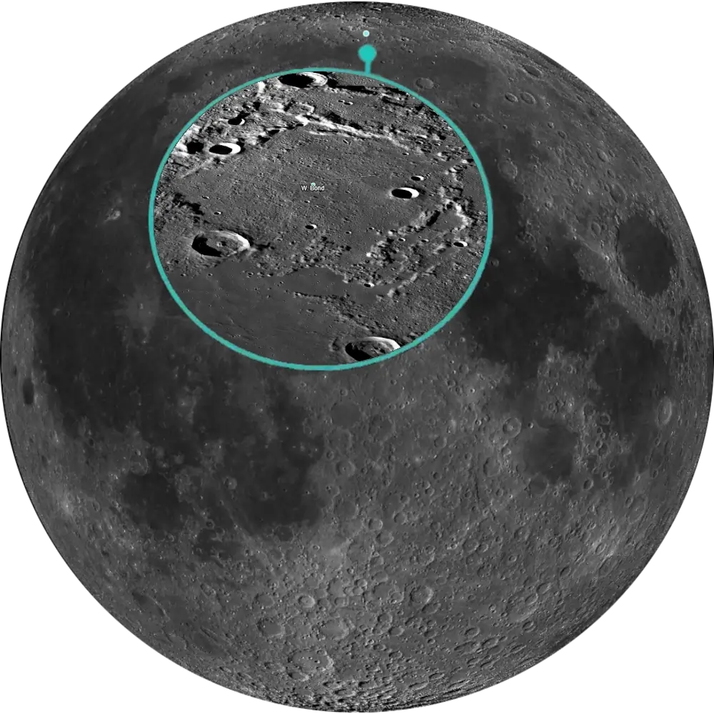
L76 W. Bond
Northern Highlands · Pre-Nectarian Walled Plain📉 Vital Statistics
🔭 Field Notes
W. Bond sits north of Mare Frigoris, near enough to the pole that it’s a good target on nights when the Moon’s northern limb is well tilted toward Earth. Don’t expect a crisp, textbook crater rim — W. Bond’s outer wall has been worn down to little more than a broken chain of hills and mounds, with only the northwest and southeast stretches still holding a recognizable shape. The crater Timaeus forms part of its southwest wall, and Epigenes sits just off its northwest corner.
- ▶ A Rim Reduced to Rubble: W. Bond is old enough — Pre-Nectarian, more than 4 billion years — that it had already been standing for a long time before the Imbrium impact occurred. That later, more distant event still left its mark: the crater’s floor is littered with scattered blocky debris interpreted as Imbrium ejecta, material thrown here from a basin-forming impact hundreds of kilometers away.
- ▶ A Ditch Through the Debris: A narrow rille — unofficially nicknamed “Rima W. Bond” by lunar cartographer Danny Caes, though not an IAU-recognized name — runs across the crater’s floor toward its eastern rim. What makes it notable is timing: the ejecta fill on W. Bond’s floor is estimated to be roughly 2 km deep, and the rille cuts directly through it — a rare example of a linear rille or ditch cutting an already emplaced basin-ejecta fill, rather than predating it.
- ▶ A Contrast in Neighbors: Just to the east, the much younger crater C. Mayer shows sharp terraced walls and a clear central peak — a useful side-by-side reminder of just how much erosion, ejecta burial, and time separate a Pre-Nectarian relic like W. Bond from a comparatively fresh impact scar nearby.
📍 Nearby L100 Targets
- L19 Alpine Valley: The famous lunar graben slicing through the Montes Alpes, roughly 495 km almost due south — another dramatic piece of Imbrium-era tectonics, on a much smaller and sharper scale than W. Bond’s broad ejecta blanket.
- L26 Mare Frigoris: The long, arcuate “Sea of Cold” running east-west just south of W. Bond, roughly 285 km away — unlike most maria, it isn’t clearly tied to a single circular impact basin, and its origin is still debated.
- L83 Plato Craterlets: Tiny pits on the floor of the crater Plato, at the limits of telescopic detection, roughly 460 km southwest — a test of resolving power in the same general region as W. Bond’s own subtle, easily-overlooked details.
🚀 Mission Log
Target Acquisition
Head north past Mare Frigoris
Locate W. Bond on Rükl chart 4, at 65.3°N, 4.5°E, sitting north of Mare Frigoris in the far northern highlands. Use Timaeus, which forms part of its southwest wall, and Epigenes, just off its northwest corner, as anchor points — at this latitude, a night of favorable northern libration makes the whole region noticeably easier to work with.
Set expectations for a ruin, not a ring
Come in with the right mindset: W. Bond’s outer wall has been worn down to little more than a broken chain of hills and mounds, with only the northwest and southeast stretches still holding a recognizable shape. A low sun angle helps tease out what relief remains, but don’t expect the crisp, complete rim you’d get from a younger crater — this is one of the Moon’s oldest surviving large impact structures, and it looks the part.
Scan the floor for the ejecta blocks and the rille
Once you’re oriented on the broken rim, turn your attention to the floor itself: it’s littered with scattered blocky debris interpreted as ejecta thrown here from the distant Imbrium impact. Look too for a narrow rille running across the floor toward the eastern rim — unofficially known among lunar cartographers as “Rima W. Bond,” though not an IAU-recognized name. It’s a genuinely unusual sight: a linear rille cutting through an already emplaced layer of basin ejecta rather than predating it.
From W. Bond to Alpine Valley, Mare Frigoris, and Plato
South, roughly 495 km away, the Alpine Valley (L19) is the famous graben slicing through the Montes Alpes — another dramatic piece of Imbrium-era tectonics, but on a much smaller and sharper scale than W. Bond’s broad ejecta blanket. Just south, about 285 km off, Mare Frigoris (L26) is the long, arcuate “Sea of Cold” whose origin, unlike most maria, isn’t clearly tied to a single circular impact basin. And southwest, roughly 460 km away, the Plato Craterlets (L83) sit at the limits of telescopic detection — a resolving-power test in the same general region as W. Bond’s own subtle, easily-overlooked details.
📝 Observation Log — L76 W. Bond
0/4 CompleteIs W. Bond visible tonight?
W. Bond sits north of Mare Frigoris at 65.3°N, 4.5°E, far enough into the northern highlands that a night of favorable northern libration makes the whole region noticeably easier to work with. Its worn, broken rim also benefits from a low sun angle to tease out what relief remains — don’t expect the crisp ring of a younger crater, this one looks its age.
Check Moon Phase TodayReturn to the List
Ready to find the next target? Go back to the full map to see what else is visible tonight.
← Back to Lunar 100 Map
When to Observe W. Bond
W. Bond sits far enough north that this is a two-part timing problem: favorable libration to bring the whole region into better view, and a low sun angle to tease out what little relief its worn rim has left.
- Wait for Favorable Northern Libration: At 65.3°N, a night of favorable northern libration makes the whole region noticeably easier to work with — check a libration calendar before planning a session.
- Use Timaeus and Epigenes as Anchors: Use Timaeus, which forms part of W. Bond’s southwest wall, and Epigenes, just off its northwest corner, to get your bearings before you go hunting for fainter detail.
- Set Expectations for a Ruin, Not a Ring: A low sun angle helps tease out what relief remains, but don’t expect the crisp, complete rim you’d get from a younger crater — this is one of the Moon’s oldest surviving large impact structures, and it looks the part.
What to Look For
W. Bond’s outer wall has been worn down to little more than a broken chain of hills and mounds. The northwest and southeast stretches are the most recognizable surviving sections, while much of the rest has been worn into an irregular, notched ring.
Look for scattered blocky debris across the floor, interpreted as ejecta thrown here from the Imbrium impact hundreds of kilometers away — a later, more distant event that still left its mark on terrain far older than itself.
Look for a narrow rille running across the floor toward the eastern rim — unofficially nicknamed “Rima W. Bond” by lunar cartographer Danny Caes, though not an IAU-recognized name. It’s a genuinely unusual sight: a linear rille cutting through an already-emplaced layer of basin ejecta rather than predating it.
Just to the east, the much younger crater C. Mayer shows sharp terraced walls and a clear central peak — a useful side-by-side reminder of just how much erosion, ejecta burial, and time separate a Pre-Nectarian relic like W. Bond from a comparatively fresh impact scar nearby.
The Science: A Ruin Older Than Imbrium’s Ejecta
W. Bond had already been standing for a very long time before the Imbrium impact ever happened — and the debris that impact left behind is now one of the clearest things left to see here.
Vital Statistics
Located at 65.3°N, 4.5°E on Rükl chart 4, W. Bond is a heavily degraded Pre-Nectarian walled plain 158 km across — one of the Moon’s oldest surviving large impact structures, dating from the Moon’s earliest geological history. Its L100 distinction: a clear, high-latitude example of how far a giant basin impact’s ejecta can travel and reshape older terrain.
A Rim Reduced to Rubble
W. Bond is old enough — Pre-Nectarian, dating from the Moon’s earliest geological history — that it had already been standing for a long time before the Imbrium impact occurred. That later, more distant event still left its mark: the crater’s floor is littered with scattered blocky debris interpreted as Imbrium ejecta, material thrown here from a basin-forming impact hundreds of kilometers away.
A Ditch Through the Debris
The ejecta fill on W. Bond’s floor is estimated to be roughly 2 km deep, and the unofficially-named “Rima W. Bond” cuts directly through it — a rare example of a linear rille or ditch cutting an already-emplaced basin-ejecta fill, rather than predating it.
Mission Record
Lunar Orbiter’s 1966–1967 photographic mapping documented the heavily degraded morphology of W. Bond. Clementine’s 1994 global multispectral and altimetry datasets added modern geological and topographic context to the northern highlands, including this heavily degraded Pre-Nectarian terrain. ESA’s SMART-1, in 2006, imaged W. Bond alongside the neighboring crater C. Mayer with its AMIE camera, part of a composite view (with Clementine data) capturing the contrast between W. Bond’s rough, degraded interior and the smoother surrounding plains, including the narrow east-running rille.
Most Lunar 100 targets show you a single moment in the Moon’s history. W. Bond shows you two stacked on top of each other — an ancient walled plain that was already ruins long before a distant, younger basin impact scattered its debris across the floor and, somehow, a rille still found a way to cut through all of it afterward.