☽ Best Places to View the Moon in Little Rock
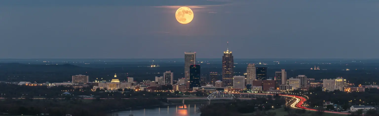
Little Rock sits in the Arkansas River Valley at the eastern edge of the Ouachita Mountains — a capital city with more geographic personality than most. The Arkansas River bends through the city from west to east, giving a broad waterfront horizon, and twenty minutes to the west Pinnacle Mountain rises 1,011 feet from the river bottoms as the easternmost peak of the Ouachitas. Between the river and that peak, the city has built its skyline and its history: the Arkansas State Capitol dome commands the hilltop above the river, the Clinton Presidential Library and River Market district line the water's edge, and two outstanding natural parks bracket the metropolitan area. Little Rock moonrises can be quiet river compositions or elevated summit panoramas — the fish pond reflections of MacArthur Park or the full sweep of the Arkansas River valley from Pinnacle Mountain, with Lake Maumelle glittering to the northwest and downtown's Capitol dome glowing to the east.
MacArthur Park – Fish Pond & Open Grounds
Little Rock's oldest municipal park and the most layered moonrise viewpoint in the city. MacArthur Park covers 36 acres at 9th and McAlmont — the site of the Little Rock Arsenal since 1840 and a public park since 1892 — and includes the Arkansas Museum of Fine Arts, the MacArthur Museum of Arkansas Military History, a WPA-era fish pond, contemplation gardens, and open lawn. The moon rises over the downtown skyline to the east with the pond providing a still-water reflection on calm evenings. The park is surrounded by the Capitol district and the skyline. Free, open 24/7; parking on surrounding streets.
River Market District – Arkansas Riverfront
The River Market District and the Clinton Presidential Library area line the south bank of the Arkansas River with one of the most walkable urban riverfronts in the mid-South. The moon rises over the water to the east — the North Little Rock skyline and the Big Dam Bridge visible downstream — with the river surface providing the clearest reflections in the metro on calm evenings. The Library's distinctive glass-and-steel cantilevered structure and the river bridges add architectural foreground. Free, open 24/7; parking in the River Market lots.
Pinnacle Mountain State Park – Summit
The highest accessible viewpoint near Little Rock. Pinnacle Mountain rises 1,011 feet above sea level — 756 feet above the adjacent river bottoms — about 20 minutes west of downtown. From the summit, the panorama takes in the Arkansas River valley, Lake Maumelle to the northwest, and the distant Little Rock skyline to the east; the moon rises over the city with the full valley in the foreground. The West Summit Trail (1.5 miles, steep) or East Summit Trail reaches the top. Free — no parking fee or admission charge. Park gates close one hour after sunset; a day-use only park, no overnight camping.
Two Rivers Park – Western Trails & Peninsula
A 1,000-acre park at the confluence of the Arkansas and Little Maumelle Rivers, about 15 miles northwest of downtown. Two Rivers Park occupies a wooded floodplain peninsula where the two rivers meet, giving open water views in multiple directions. The moon rises over the Arkansas River to the east and southeast, with open fields providing an unobstructed low horizon and the I-430 bridge visible in the distance. One of the darkest parkland positions in the metro — 1,000 acres of bottomland with minimal surrounding light pollution. Free, open 24/7; two parking areas off Two Rivers Park Road and County Farm Road.
Arkansas State Capitol Grounds
The Arkansas State Capitol, completed in 1915 and modelled after the US Capitol in Washington, commands a hilltop above the Arkansas River and is one of the most beautifully sited domes in the American South. From Capitol Avenue and the surrounding grounds, the moon rises over the city to the east while the dome is illuminated in the foreground — the same bilateral composition axis as the Buenos Aires Palacio Barolo or the Jackson State Capitol, but in a smaller and more intimate city. The Capitol Mall provides a long eastern sightline. Grounds accessible at all hours; building open weekdays. Free; street parking and Capitol lots.
War Memorial Park – Open Fields
War Memorial Park is a large west Little Rock park adjacent to War Memorial Stadium — the home of Arkansas Razorbacks football — with open lawns, tree lines, a golf course, and wide eastern sightlines back toward downtown. The moon rises over the city skyline and Capitol dome from a quieter residential-park setting than the downtown positions. Less dramatic than the riverfront or Pinnacle Mountain, but darker, easier to access, and well suited to photographers who want a longer, unhurried session away from the river wind. Free, open 24/7; generous parking in the stadium and park lots.
◉ Best Times for Moon Photography
📷 Quick Photography Tips
Little Rock operates on CST (UTC−6) in winter and CDT (UTC−5) during daylight saving time. Clocks go forward on the second Sunday in March and back on the first Sunday in November. Arkansas observes DST statewide. Apps like PhotoPills or Stellarium set to Little Rock apply the correct offset automatically — useful for calculating exact moonrise times against the Capitol dome and river horizon throughout the year.
For the moon phase in any other city worldwide, visit our Dynamic Moon Phase Calculator for instant lunar data tailored to wherever you are.
The moon phase today in Little Rock, AR is shown in detail above — complete with exact illumination percentage, moonrise/set times, and the best local spots to see it. For the moon phase today in any other city or location worldwide, visit our Dynamic Moon Phase Calculator on the home page.
◐ What the Experience Actually Feels Like
Little Rock's geography does something unusual for a Southern state capital: it puts a mountain in the frame. Twenty minutes west of downtown, Pinnacle Mountain rises from the Arkansas River bottomlands in a shape so clean and symmetrical — a cone of Ouachita sandstone lifting 756 feet from the surrounding flats — that early French settlers called it "Mamelle," their word for a breast-shaped hill. From the summit, you look east over the Arkansas River valley and the distant Little Rock skyline, and the moon rises out of that eastern sky over a city you drove through an hour ago. The view is genuinely panoramic: Lake Maumelle to the northwest, the river bending through the valley below, the Ouachita ridges behind you. It is not a small experience for a free state park within twenty minutes of a capital city.
Down at river level, the Clinton Presidential Library's glass-and-steel cantilevered structure and the pedestrian bridges of the River Market give Little Rock a waterfront that most medium-sized American cities would envy. The Arkansas River is wide here — wide enough that the far bank in North Little Rock provides a genuine reflected skyline on still evenings — and the Big Dam Bridge downstream is one of the longest pedestrian bridges in the country, lit at night and giving a secondary compositional element that draws photographers who work the river corridor systematically. The moon rises over the water and the bridge cables, and on the right October evening the river goes so flat that the whole composition doubles below you.
MacArthur Park is the quieter, more intimate third mode. The WPA-era fish pond catches the moon after it has cleared the downtown towers, and the Tower Building of the old Little Rock Arsenal — a National Historic Landmark that General Douglas MacArthur was born in, in 1880 — stands at the edge of the park as the kind of modest but genuine historic anchor that most parks lack. The park is 36 acres of history and green space in the middle of a mid-sized Southern capital, and the moon, rising over the skyline with the pond catching it below, is precisely what you came for.
"From the Pinnacle Mountain summit you look east over the Arkansas River valley and the distant Little Rock skyline, and the moon rises out of that eastern sky over a city you drove through an hour ago — panoramic, free, twenty minutes from downtown."
✓ Your Little Rock Moon Chase Checklist
Before You Go
- Check the moonrise time and phase on this page — the azimuth shifts significantly through the year, and aligning the moon with the Capitol dome from the Capitol grounds or the river from the Clinton Library area benefits from PhotoPills planning
- Target the 48–72 hour window before full moon — the moon rises during golden and blue hour, and the warm Arkansas River light on the Capitol dome and bridges gives the scene its richest colour
- If planning Pinnacle Mountain, note that park gates close one hour after sunset — plan your ascent and descent timing carefully to be off the summit trail before the gate closes; the summit climb is steep and requires care in the dark
- Check wind conditions for the Arkansas Riverfront and MacArthur pond — calm nights only produce the mirror reflections that make these compositions exceptional; even a light breeze breaks them
- Two Rivers Park is about 15 miles northwest of downtown — plan drive time accordingly and bring a torch; the trails through the bottomland and fields are not lit at night
What to Bring
- Sturdy tripod — river wind along the Arkansas Riverfront is persistent at the River Market and Clinton Library positions; Pinnacle Mountain summit is fully exposed to prevailing westerlies
- A telephoto lens (200–400mm) for the Capitol dome and Pinnacle Mountain summit — compressing the moon against the dome from the Capitol grounds, or compressing the Little Rock skyline from the summit, rewards longer glass significantly
- A wide-angle lens (16–35mm) for the Arkansas Riverfront and MacArthur pond — the bridge structures, river width, and pond foreground suit shorter focal lengths that include water, bridges, and rising moon together
- Solid hiking shoes for Pinnacle Mountain — both summit trails are steep, rocky, and uneven; trainers are inadequate and the descent in fading light requires ankle support
- Insect repellent from April through October — Two Rivers Park and the Arkansas River bottomlands at MacArthur have significant mosquito activity after dark in warm months
- Water for Pinnacle Mountain — the summit climb is a genuine physical effort of 1.5 miles each way with significant elevation gain; dehydration accelerates in the Arkansas summer heat
On the Night
- Arrive at your viewpoint 30–45 minutes before moonrise — the sky over the Arkansas River valley transitions through a warm amber-to-indigo gradient, and the Capitol dome or bridge silhouettes against the pre-moonrise sky are compositions worth capturing before the moon appears
- At the Clinton Library riverfront, position yourself on the Arkansas River Trail east of the Library for the best combined view of the river surface, the downtown skyline, and the moon clearing the North Little Rock bank
- At MacArthur Park, position yourself on the western side of the fish pond facing east — the moon rises over the downtown skyline and reflects in the pond below in a composition anchored by the Museum of Fine Arts building and the Tower Building to one side
- Shoot RAW throughout — the dynamic range between the moon, the Capitol dome lighting, the river surface, and the dark tree lines requires separate exposures carefully blended in post
- Stay 20–30 minutes after moonrise — the moon clears the river valley horizon haze quickly in autumn and winter, and the Capitol dome and river bridge compositions tighten and sharpen as it climbs above the ambient glow
Moon Phase Today Little Rock

Weather in Little Rock
Loading Little Rock conditions...