
L86 Prinz Rilles
A branching network of sinuous channels spilling north of a drowned crater on Oceanus Procellarum — lava carved this snake-shaped rille, not a collapsed tube.
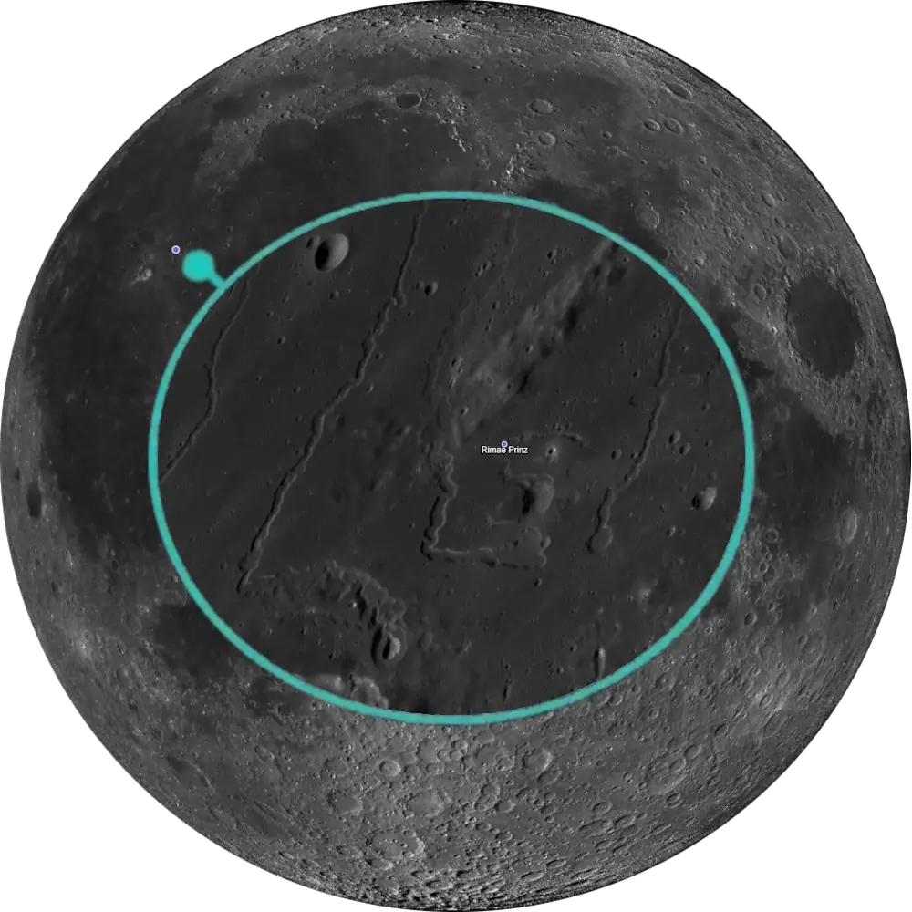
L86 Prinz Rilles
Oceanus Procellarum · Sinuous Rille System📉 Vital Statistics
🔭 Field Notes
Prinz itself is unremarkable — the drowned remnant of an old impact crater on Oceanus Procellarum, its rim intact only along the northeast, with its southern rim largely absent following later mare flooding. What draws observers here is the tangle of channels spilling across the mare just north of its rim: the Rimae Prinz, a family of sinuous rilles that rank among the finest examples of lunar volcanic channels anywhere on the near side. The main channel begins near the volcanic pit Vera, while the nearby crater Ivan forms part of the broader source region, and the rilles snake outward across the lava plain in loops and branches unlike anything a straight tectonic rille produces.
- ▶ A Snake Born of Fire Fountains: The rilles’ primary source vent, the small crater Vera just north of Prinz’s rim, is widely interpreted as the site of a lava lake created during fire-fountain eruptions, comparable to Hawaii’s Mauna Ulu but on a far larger scale. From there the channel runs roughly 75 km, first west and then turning sharply north, giving the whole system the look of a snake with its head at Prinz and its body curling across the mare.
- ▶ Carved, Not Collapsed: Modeling of the main channel shows steep, well-preserved walls with little sign of slumping, evidence that thermal erosion by hot flowing lava — rather than the roof collapse of a buried lava tube — did most of the excavating. Scaled against terrestrial channels, the result is a rille that dwarfs typical lava channels on Earth by orders of magnitude in both depth and length.
- ▶ A Naming History as Tangled as the Rilles: The two classic channels were once cataloged simply as Rima Prinz I and II, and later mapping briefly floated the names Beethoven, Handel, and Telemann for individual branches — none of which the IAU ever adopted. The whole family now carries the plural designation Rimae Prinz, a tidier label for a genuinely intricate piece of terrain.
📍 Nearby L100 Targets
- L11 Aristarchus: The brightest large crater on the Moon, roughly 150 km southwest on the Aristarchus Plateau. Its own rille system, Rimae Aristarchus, lies just northwest of the crater and is generally regarded as part of the same extensive volcanic province that produced Rimae Prinz.
- L17 Schröter’s Valley: The Moon’s largest sinuous rille, roughly 160 km long, beginning at the “Cobra Head” pit north of Herodotus crater some 150 km southwest of Prinz. Where Rimae Prinz shows a modest fire-fountain channel, Schröter’s Valley shows what the same process can do at its most extreme.
- L49 Gruithuisen Delta & Gamma: A pair of steep-sided silicic domes roughly 290 km north of Prinz, on the border of Mare Imbrium. Where Rimae Prinz records fluid basaltic lava carving a channel, Gruithuisen’s domes record the opposite extreme — thick, silica-rich lava piling up into mountains instead of flowing away.
🚀 Mission Log
Target Acquisition
Find the Aristarchus Plateau, then look just east
Locate the bright Aristarchus Plateau in Oceanus Procellarum — hard to miss even under high sun. About 100 km east of it sits the horseshoe-shaped, drowned crater Prinz, its rim most intact along the northeast, with a broad gap in the south wall. The rilles you’re actually after, the Rimae Prinz, spill across the mare just north of that rim rather than inside the crater itself.
Time it to catch morning light on the plateau
Target this region around the waxing gibbous Moon, when morning sunlight first reaches the Aristarchus Plateau and the terminator sits close enough to throw shadow into the rilles (the equivalent point in the waning cycle works too). Too much later and the low, sinuous channels start to wash out against the surrounding mare.
Bring more aperture than you’d think you need
A 100 mm scope is enough to resolve Schröter’s Valley nearby, but the narrower rilles between Prinz and Krieger typically call for something in the 250 mm (10″) class to really open up. Once you’re on target, trace the channel from the small crater Vera at Prinz’s rim — the system’s source depression — running about 75 km, first west and then turning sharply north, giving the whole system the look of a snake with its head at Prinz and its body curling across the mare.
From Rimae Prinz to Aristarchus, Schröter’s Valley, and Gruithuisen
Roughly 150 km southwest, Aristarchus (L11) is the brightest large crater on the Moon, its own Rimae Aristarchus generally regarded as part of the same volcanic province that produced Rimae Prinz. Also to the southwest, Schröter’s Valley (L17) is the Moon’s largest sinuous rille, beginning at the “Cobra Head” pit — where Rimae Prinz shows a modest fire-fountain channel, this one shows what the same process can do at its most extreme. And roughly 290 km north, on the border of Mare Imbrium, Gruithuisen Delta & Gamma (L49) are steep-sided silicic domes — the opposite extreme from Rimae Prinz’s fluid basaltic lava, with thick, silica-rich lava piling up into mountains instead of flowing away.
📝 Observation Log — L86 Prinz Rilles
0/4 CompleteAre the Prinz Rilles visible tonight?
Rimae Prinz spills across Oceanus Procellarum just north of the crater Prinz, near 27.0°N, 43.0°W. Time a session for the waxing gibbous Moon, when morning sunlight first reaches the Aristarchus Plateau (the equivalent point waning also works) — wait too long and the low, sinuous channels wash out. Bring 250 mm-class aperture to open up the narrower branches.
Check Moon Phase TodayReturn to the List
Ready to find the next target? Go back to the full map to see what else is visible tonight.
← Back to Lunar 100 Map
When to Observe Rimae Prinz
Rimae Prinz rewards the same terminator-chasing instinct that works on most Lunar 100 targets, but adds a second requirement most rille systems don’t: real aperture. The channels are there under the right light — the trick is resolving them once you find them.
- Catch Morning Light on the Aristarchus Plateau: Target this region around the waxing gibbous Moon, when morning sunlight first reaches the Aristarchus Plateau and the terminator sits close enough to throw shadow into the rilles (the equivalent point in the waning cycle works too). Too much later and the low, sinuous channels start to wash out against the surrounding mare.
- Bring More Aperture Than You’d Think You Need: A 100 mm scope is enough to resolve nearby Schröter’s Valley, but the narrower rilles between Prinz and Krieger typically call for something in the 250 mm (10″) class to really open up.
- For Orientation: Find the drowned crater Prinz on Oceanus Procellarum, about 100 km east of the bright Aristarchus Plateau. The rilles themselves spill across the mare just north of Prinz’s rim, not inside the crater.
What to Look For
Trace the channel from the small crater Vera, the source depression at Prinz’s rim, running roughly 75 km — first west, then turning sharply north — giving the whole system the look of a snake with its head at Prinz and its body curling across the mare.
Look for the channel’s steep, well-preserved walls, with little sign of slumping along their length — consistent with carving by hot flowing lava rather than being primarily a collapsed lava tube.
Watch for the branching, looping pattern that sets Rimae Prinz apart from an ordinary straight tectonic rille — a genuinely intricate piece of terrain rather than a single simple channel.
Scaled against terrestrial lava channels, Rima Prinz’s main channel is a rille that dwarfs typical lava channels on Earth by orders of magnitude in both depth and length — a scale worth holding in mind while tracing it at the eyepiece.
The Science: A Fire-Fountain Channel
Rimae Prinz isn’t just a pretty tangle of channels — it’s read as a record of how fluid basaltic lava can carve, rather than merely fill, the lunar surface.
Vital Statistics
Prinz is located at 27.0°N, 43.0°W, on Rükl chart 19, a 46 km lava-flooded crater with its rim intact only along the northeast, the southern rim largely erased by later mare flooding. The associated rille system, Rimae Prinz, runs roughly 75–80 km. Named for Wilhelm Prinz (1857–1910), the crater’s L100 distinction is the rille system found near it — a sinuous channel network rather than the crater itself.
A Lava Lake at the Source
The rilles’ primary source vent, the small crater Vera just north of Prinz’s rim, is widely interpreted as a volcanic source vent that may have hosted a lava lake during fire-fountain eruptions, comparable to Hawaii’s Mauna Ulu but on a far larger scale. Modeling of the main channel is consistent with thermal erosion by hot flowing lava as the dominant carving process, rather than the collapse of a buried lava tube.
A Naming History as Tangled as the Rilles
The two classic channels were once cataloged simply as Rima Prinz I and II, and later mapping briefly floated the names Beethoven, Handel, and Telemann for individual branches — none of which the IAU ever adopted. The whole family now carries the plural designation Rimae Prinz, a tidier label for a genuinely intricate piece of terrain.
Mission Record
Lunar Orbiter imagery from 1966–67 revealed much of the full extent of the Rimae Prinz channel network, showing its branching, looping pattern in greater detail than Earth-based observation had achieved. Apollo 15 Command Module Pilot Alfred Worden photographed Prinz and its rilles from orbit in 1971 (frame AS15-93-12608), imagery still used as a reference view of the system. Lunar Reconnaissance Orbiter, combining LROC imagery with LOLA laser altimetry, has since been used to build detailed topographic models of Rima Prinz and its source depression Vera, underpinning modern thermal-erosion studies of how the channel formed.
Most Lunar 100 rilles are studied for where the lava went. Rimae Prinz is studied for how it got there — a channel generally interpreted as lava-eroded rather than a classic collapsed lava tube, still legible across the mare nearly four billion years later.